Gorontalo is a province of Indonesia on the northern part of Sulawesi island. Gorontalo province was established in December 2000 after splitting from North Sulawesi province. The capital is a city with the same name, Gorontalo.
Etymology
There are various opinions concerning the origin of the name Gorontalo:
* derives from Hulontalangio, a name of a tribe that resided in the area
* derives from Hua Lolontalango, which means cavemen who used to walk back and forth
* derives from Hulutalangi, which means nobler
* derives from Huluo Lo Tola, which means a place where snakehead fish breed
* derives from Pongolatalo or Pohulatalo, which means: a waiting place
* derives fron Gunung Telu, which means three mountains
* derives from Hunto, which means a place that is always flowed by water
Geography
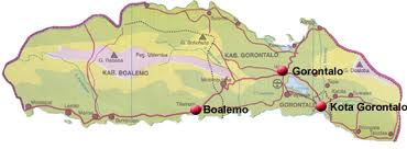
Gorontalo province lies on the northern Sulawesi arm, known as the Minahassa Peninsula. The province has an elongated shape area , stretching from west to east almost horizontally on a map, with total area of 12,215.44 km2 (4,716.41 sq mi). To the north and the south of the province are the Sulawesi Sea and the Gulf of Tomini, respectively. Prior to 2000, Gorontalo province was part of North Sulawesi province on the eastern border. The western border of the province is Central Sulawesi province.
Topography of the province is relatively low (0—40o), with the elevation ranging between 0—2,400 m (7,874.02 ft) above sea level. Its coastline length is more than 590 km (366.61 mi). Counting the Exclusive Economic Zone to the north where Philippines is at the border, the total sea area of the province is more than 50,500 km2 (19,498.16 sq mi). There are some small islands around the north and the south of the province, 67 of which have been identified and named.
Its population has grown from 840,000 in the 2000 census to 1,038,590 for the 2010 census, with nearly half the population residing in Gorontalo Regency or City.
History
Pre-Independence
In 1525, with Portuguese assistance, three small rock forts were built overlooking the waters of Lake Limboto. Still in place today, the Fort Otonaha complex has commanding views.
The Spanish also entered the area in limited numbers via the Philippines during the mid-16th century. They introduced corn, tomatoes, chili peppers, horses, and the afternoon siesta to Gorontalo, all of which are an integral part of life there today.
The Dutch under the aegis of the United East India Company (VOC) worked to wrest control of the lucrative spice trade away from the Sultanate of Ternate and push out all other European competitors. Gradually, the Dutch gained political control and ended the power of the local kings.
Independence
The people of Gorontalo achieved independence from Dutch rule in 1942. This was partly through the efforts of the guerrilla/freedom fighter and local hero Nani Wartabone, who forced out the occupying Japanese during World War II.
Since the city escaped Allied bombing during the war, a number of Dutch-era buildings are still standing. Although many are in poor condition, Gorontalo City has a distinctive colonial appearance.
Post Independence of Indonesia
After Indonesia proclaimed its independence, Gorontalo became part of North Sulawesi province. Gorontalo seceded from North Sulawesi province in 2000.
Administration
The governor and vice-governor, who are elected directly by the people, head the provincial administration. The province is divided into five regencies (Indonesian: kabupaten) and only one city (Indonesian: kota). When it was established in 2000, there were only two regencies and one city in the province. Several splitting of regencies occurred in 2003 and 2007. As of 2007, the list of regencies and cities in Gorontalo province is given in the table below. (Source: Wikipedia)